


OK, that one was easy. Of course, we are in Chicken, AK, population of 20-30 in the summer, 15 in the winter.


This one is harder. But if it looks like we’re on the top of the world, you’re right! This is the Top of the World Highway.
Chicken was on our list to visit. It’s kind of out of the way, but our trip to WEIO (World Eskimo Indian Olympics) put us kinda sorta in the neighborhood. A little less than 300 miles from Fairbanks, actually, but as large as Alaska is, that’s in the neighborhood. Looking at a map, more treasures were revealed. Chicken was close to the Top of the World Highway, which leads to Dawson City, Yukon, which is reached by crossing the Yukon River on a ferry. Sounded fun and definitely an adventure not to be passed on.
It would be a full day, almost 400 miles of driving, so we set our alarms and left Fairbanks at 5:20am. We drove through North Pole and waved at the reindeer. Around 9:00 we stopped in Tok at the Shell station to fill up one tank and empty another. Shortly past Tok we made the left hand turn onto the Taylor Highway towards Chicken. The “Highway” was decent, mostly paved with a tolerable amount of potholes. Sixty+ miles to Chicken!
Chicken is now some gifts shops, a campground, old mining relics and porta potties, but in 1903 it had a population of around 400, mostly miners, prospectors and some natives. Big enough community to deserve a name, and it was decided to call the town Ptarmigan because the plentiful local birds filled many a pot in the camps. However, no one knew how to spell Ptarmigan, so someone allegedly said “Aw hell, let’s just call it Chicken.” And so it was. Chicken has no telephones and no flush toilets. They have pretty fancy porta potties, though.


We took numerous chicken pictures, bought some souvenirs, had a nice lunch on the deck of Chicken Gold Camp and Outpost, the gift shop/lunch bar, and headed out of town to experience the Top of the World Highway. About 100 miles to Dawson City.


Top of the World Highway was build in 1955. It was paved in the 1990s but hasn’t been well maintained, so it’s now mostly gravel. It is a curvy, pot-holed road that winds around the peaks and crests of the mountains. It is, in fact, one of the most northernly highways in the world at that altitude. No guard rails, but plenty of spectacular views of the Alaska Range. The road is only open in summer months and many rental companies don’t allow their vehicles to be driven on this road. We had read the road could be challenging, but the McCarthy Road in Wrangell-St. Elias had been similarly described, and we took it slow and had no problems there, so we felt up to the challenge.
We had good weather, which we were thankful for. At first, used to the dramatic mountain peaks around Anchorage and much of southwest Alaska, I didn’t appreciate what I was seeing. Didn’t take long, though, for the views to grab me. Sal counted at least seven mountain ridges at one spot. The views were forever.


Sal had asked if I wanted to drive some on the highway, and I said I did. However, we were not too long on the road when I changed my mind. We were really high up. Hairpin curves and no guard rails? No thanks.
The trip is around 80 miles long. We had no problems. We took our time and enjoyed the views. We saw people in two spots by rivers panning for gold. Maybe halfway into the trip, we crossed over into Canada. The customs lady was nice, and I took the opportunity to asked a couple border crossing questions relating to Grey and the moose antler we will be bringing back for our new nephew Fuzz. It was the Little Gold/Poker Creek border crossing, which is the northernmost international border crossing in North America. Sal and I had considered coming this route when we head back to Virginia in late September, but the border closes this year around the first of September. The highway also is seasonal, only open mid May to mid September.


After about 2-1/2 hours, we arrived at the George Black ferry, which would take us across the Yukon River to Dawson City. There was a line of cars and RVs waiting to cross, but the trip is short, only about 8 minutes, and we were driving the dirt streets of Dawson City about 30 minutes later around 4:30. We had entered a new time zone and so the trip had actually taken us about 10 hours. The Main Street of Dawson City is the only paved road in town. The permafrost is so bad the ground shifts frequently enough that buildings are constructed in such a way that they can be lifted and realigned every year. We saw some early buildings without that construction feature that were tilting so badly they were practically falling down.


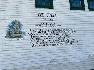
We went immediately to the Visitor’s Center to get tickets for the 6:00 Klondike National Historic Site walking tour. We were leaving early the next day, and we were tired, so the tour would be about the extent of our sightseeing in Dawson City. The tour was interesting. The town was the center of the Klondike gold rush, and many buildings have been restored to reflect the time. We went in a bank and saloon and heard stories of miners, the working women of the town and Jack London, writer, and Robert Service, poet, who each had lived and written about life in the Yukon. We learned about a drink you can get around town, a Sourtoe Cocktail. It has an actual preserved human toe in it. If you drink it and your lips touch the toe, you become a member of the Sourtoe Cocktail Club and receive a certificate of membership. That’s one of the grossest things I’ve ever heard. After the tour, Sally and I went to Bombay Peggy’s (“Victorian Elegance in Dawson City”) where we enjoyed normal people drinks. And country music, our favorite. A nice way to relax at the end of a long day.
The only fingers are mine!


Long day ahead, but we slept later and left the hotel around 9:00. We stopped at a bakery and got coffee and a variety of yummy treats to get us going. We lined back up for the ferry, again crossing in less than 30 minutes. Then we retraced our route from yesterday over the mountains and through Chicken to Tok, then turned left toward Glenallen and Anchorage.

One fun thing; shortly after we crossed back into the US, we pulled over at a scenic view. There was a biker there, setting up his phone to take a selfie. I offered to take the picture and we ended up talking at length to Peter, owner of Johnny’s Bar and Grill, a biker bar in Hollister CA (https://benitolink.com/historic-hollister-biker-bar-johnnys-changes-hands/). It has quite an interesting history. Peter was heading up to the North Slope on his bike. Apparently there is a bar there where people leave stickers of other bars. Johnny’s was not represented, and he was riding thousands of miles north to correct that. It was fun talking with him. He seemed a really nice guy and was interested in our trip.


Sal got us home by 9:00. Grey was glad to have us home. We’ll be home for a couple weeks until our next trip. We leave Alaska in two months and will use this time to start seriously planning our return. Mixed feeling. It’s been a fabulous year here.


.jpg)
No comments:
Post a Comment